
CounterTerraRisk Solutions
CounterTerraRisk Solutions
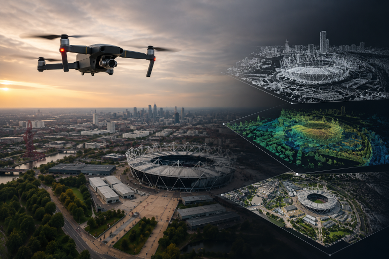
Modern security and risk assessments demand more than written observations and static photographs. Our drone-enabled surveying and photogrammetry services provide clients with a detailed visual and spatial understanding of their environment, supporting better decision-making, planning and risk reduction.
CounterTerraRisk Solutions uses professional drone platforms to capture high-resolution aerial imagery and generate accurate 2D and 3D site models. This enable organisations to visualise complex spaces from an operational perspective, identify vulnerabilities, analyse movement and access routes, and support planning for security, resilience and infrastructure protection.
Our approach combines aviation capability with operational security experience. We do not simply collect imagery. We interpret environments through protective security and risk lens.
Using photogrammetry techniques, we convert overlapping aerial imagery into accurate digital models and mapping products.
Outputs can include:
These models suport both strategic and operational activity. They allow stakeholders to visualise enviornments in detail, conduct remote analysis, identify vulnerabilties and improve planning beofre works or operations begin.
For complex or high footfall environments, 3D modelling can significantly improve understanding of crowd dynaics, visibility, choke points, vehicle routes and vulnerable locations.
We conduct aerial photography and video capture to support:
High-quality aerial imagery provdes a perspective that cannot be achieved effectively from the ground. It enables organisations to understand relationships between structures, terrain, access routes, public spaces and surrounding infrastructure in a clear and actionable way.
Aerial intelligence and 3D modelling provide clarity that traditional assessments alone often cannot achieve. They enable organisations to move beyond assumptions and understand their environment with precision.
Better understanding leads to better decisions, stronger security measures and more effective planning.
Whether supporting protective security, infrastructure planning, emergency preparedness or operational assurance, our drone-enabled assessment capability provides a modern and practical enhancement to risk management.
We need your consent to load the translations
We use a third-party service to translate the website content that may collect data about your activity. Please review the details in the privacy policy and accept the service to view the translations.